Research highlights
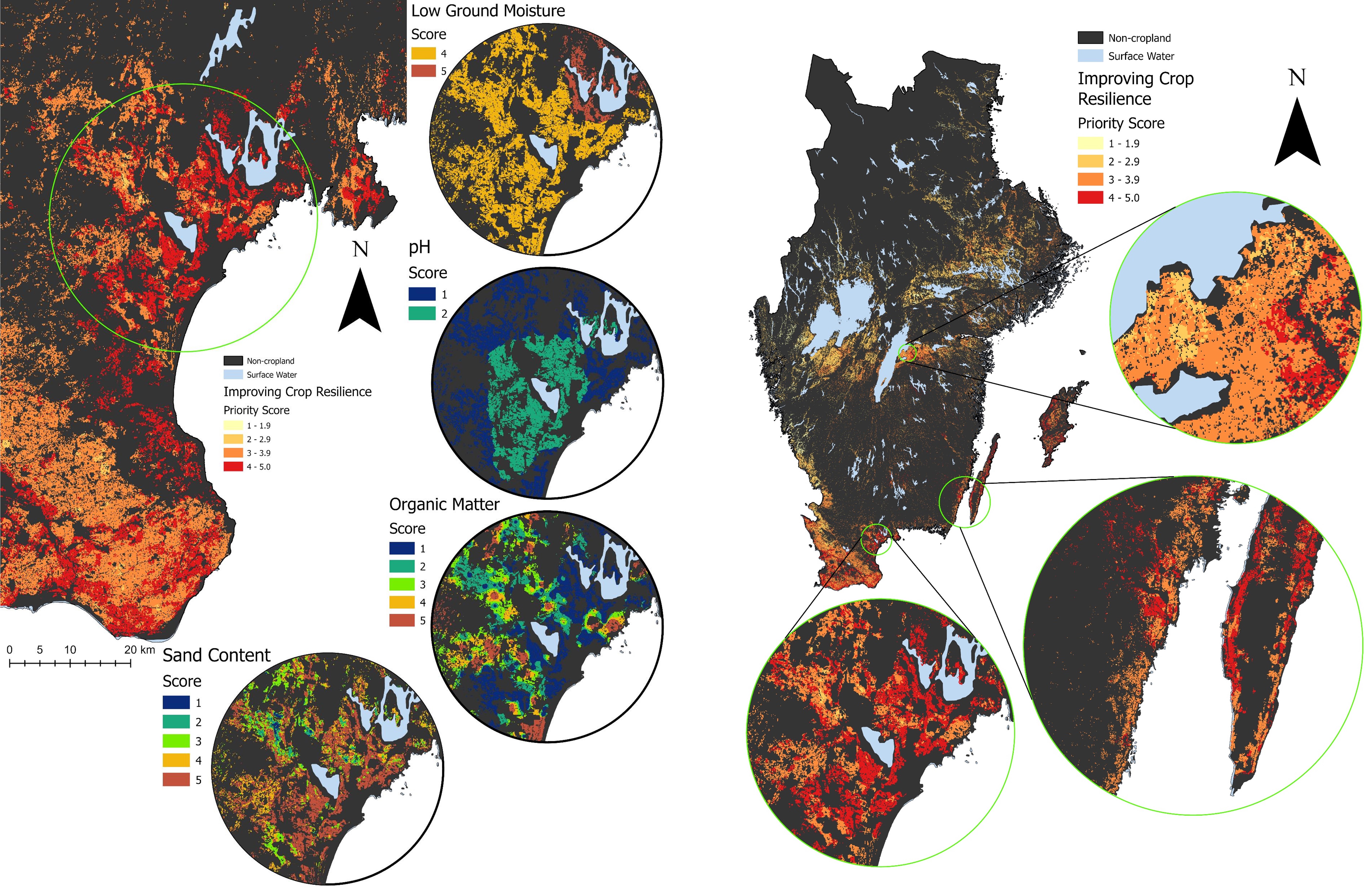
- We have designed multiple narratives of biochar use in agricultural soils, reflecting either 1) improving soil quality, 2) improving crop resilience, and 3) reducing nitrogen leaching
- We have compiled spatial data (maps) of Swedish soil and climate such as: soil pH, soil organic matter, soil texture, nitrogen leaching estimates from SMED and low soil moisture estimates from SMHI
- Coupling multi-criteria analysis with expert knowledge on biochar-soil interactions, we provide indications on where to prioritize biochar use for each narrative.
- For all the narratives, we found that a significant fraction of the Swedish arable land could potentially benefit from biochar application. Furthermore, arable land that scored high for a given narrative did not necessarily score high in the others, thus indicating that biochar application schemes can be adjusted to various objectives and local needs.
- Overall, the results of this study indicate that a priority-based framework for biochar application could help identify the magnitude and location of areas where biochar application could be beneficial.
- In the next step, we will consult Swedish stakeholders for their opinion on the multi-criteria analysis and the priority maps and develep it futher through a Master’s thesis project
Resources
Reference
Karan, S. K., Osslund, F., Azzi, E. S., Karltun, E., & Sundberg, C. (2023). A spatial framework for prioritizing biochar application to arable land: A case study for Sweden. Resources, Conservation and Recycling, 189, 106769. DOI: 10.1016/j.resconrec.2022.106769
Data
The modelling was performed in ArcGIS and Microsoft Excel. The output data generated in this study is available online on Zenodo. The uploaded data contains the following:
Raster files for three different biochar prioritization narratives.
High-resolution biochar use indication maps (in JPEG) for different prioritization narratives.
Interactive map
Coming soon. A development version will be hosted on Google’s Earth Engine.
Previous work
The work presented in this paper is an extension and refinement of the work performed by:
Waila AB, https://waila.se/
Fabian Osslund, in his Master thesis project in 2020: Prioritising biochar application to arable land in Sweden: A spatial multi-criteria analysis
Want to read more?
Abstract
The biochar-agriculture nexus can potentially generate several benefits ranging from soil carbon sequestration to the reduction in nutrient leaching from arable soils. However, leveraging these benefits requires spatially-explicit information on suitable locations for biochar application.
This study provides a flexible multicriteria framework that delivers spatial indications on biochar prioritization through a biochar use indication map (BUIM). The framework was exemplified as a case study for Swedish arable land through three different prioritization narratives.
The BUIM for all the narratives revealed that a significant fraction of the Swedish arable land could potentially benefit from biochar application. Furthermore, arable land that scored high for a given narrative did not necessarily score high in the others, thus indicating that biochar application schemes can be adjusted to various objectives and local needs.
The framework presented here aims to promote the exploration of different avenues for deploying biochar in the agricultural sector.